A drone flies autonomously above a construction site, precisely delivering a brick to a designated location—researchers at Tongji University in Shanghai are turning this seemingly sci-fi scenario into reality, and the key to their success lies in a set of "piercing eyes" capable of capturing the drone's sub-millimeter position and attitude in real time.
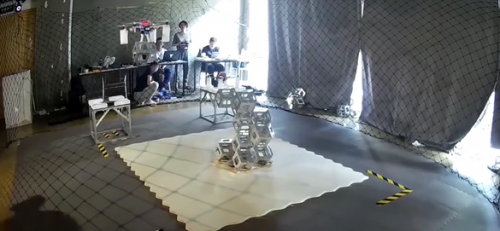
In the laboratory of the Department of Architecture at Tongji University in Shanghai, a group of researchers is changing the way future buildings are constructed. They no longer rely on traditional industrial robots; instead, they are attempting to use drone swarms for autonomous aerial construction.
One of the core challenges of this research is how to precisely obtain the real-time pose of the UAV in three-dimensional space—including its position coordinates (X, Y, Z) and attitude angles (yaw, roll, pitch).
I. Research Breakthrough: The Precision Eye of Autonomous Drone Construction
When industrial robots struggle to operate on large buildings due to limitations in size and range of motion, a research team from Tongji University has proposed an innovative solution: using drones instead of traditional robots for aerial construction. Their autonomous drone construction system consists of two core components: drone spatial pose feedback and ground station trajectory control.
The research team first set up scenarios in a limited-scale experimental site to conduct drone flight tests. By precisely acquiring the drone's spatial position and orientation data, they designed a ground station system capable of controlling the drone to complete construction tasks. This system can then be scaled up for application at real building scale.
Accurate acquisition of spatial pose has become the key to the success of the entire system. The research team at Tongji University chose the NOKOV optical 3D motion capture system as the spatial positioning solution, mainly relying on its high-precision capture capability accurate to the sub-millimeter level.
In an environment with a ceiling height of 2.5 meters and a working area of approximately 5 meters × 6 meters, the research team set up an indoor drone positioning system consisting of 8 motion capture cameras. By capturing specially designed reflective markers fixed on the drone, these cameras record the drone's position information in space at a frequency of 200 Hz.
The acquired data, after being processed by a specific algorithm, can provide real-time six degrees of freedom (6DoF) information of the drone, including 3D spatial XYZ coordinates, yaw angle, roll angle, and pitch angle.
II. Technical Core: Multiple Dimensions of Precise Pose Measurement
UAV pose measurement is a key technology in the fields of robot vision and autonomous navigation. It is not merely simple positioning, but a comprehensive description of the UAV's full state in three-dimensional space.
Six-degree-of-freedom (6DoF) pose information includes three translational degrees of freedom and three rotational degrees of freedom, which together determine the precise state of the UAV in space. Once this data is obtained, the control system can acquire it in real time and use its onboard sensor data for local position estimation calculations, which are used to update the UAV's position estimate relative to the global coordinate system in real time.
Through trajectory planning, the system can coordinate the movement patterns of multiple drones between waypoints when performing tasks such as bricklaying and material handling, ensuring the safety of the aircraft during operation and the correct bricklaying sequence.
With the support of a real-time control system and visualization interface platform for autonomous drone construction based on an indoor motion capture system, the research team at Tongji University has now completed a construction experiment carried out entirely autonomously by drones, taking a solid step toward the goal of autonomous aerial drone construction.
III. Mainstream Solutions: Comparison of the Four Leading Motion Capture Systems
In the field of precise pose measurement for drones and robots, several mainstream optical motion capture systems each have their own characteristics. In addition to the NOKOV motion capture system, there are also multiple international brands on the market offering similar solutions.
The following is a comparison of the features of four main motion capture systems:
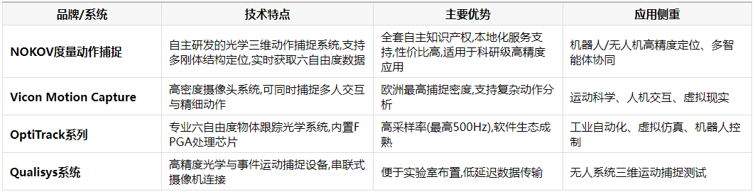
International brands have accumulated long-term experience in the motion capture field. The Vicon system features a high-density camera layout, capable of simultaneously capturing multi-person interactions and fine movements.
OptiTrack, on the other hand, is known for its high sampling rate and mature software ecosystem, making it particularly suitable for scenarios that require capturing high-speed motion trajectories.
The Swedish Qualisys system, on the other hand, focuses on adaptability to harsh environments and heavy machinery applications.
IV. Domestic Brands: Technical Advantages and Application Prospects of NOKOV Motion Capture
Among the many motion capture solutions, the NOKOV metric motion capture system, as a representative domestic brand, demonstrates unique technical advantages. The system supports one-click creation of multiple rigid bodies and features an intelligent agent cockpit graphical interface, enabling synchronized data acquisition and integrated management.
The system also supports custom model tracking and model training, making it suitable for continuum robotics, soft robotics, and bionics research. With a rich set of SDKs and plugins and comprehensive data transmission support, it can flexibly adapt to the needs of different research scenarios.
The NOKOV metric motion capture system is specifically designed for scientific research, offering resolution options from 2.2 million to 26 million pixels and a frequency range of 180Hz to 340Hz. It is considered one of the most cost-effective optical motion capture solutions currently available.
The system has a wide range of applications. It can be used not only for UAV pose measurement, but also for gait optimization of bionic robots. For example, the School of Control Science and Engineering at Shandong University used this system to capture the motion gait information of a quadruped robot for optimizing the robot's obstacle-crossing behavior.
For flapping-wing robots, the system can capture the spatial positions and orientations of both wings and the fuselage, helping researchers analyze the flapping frequency and patterns of the wings, as well as the vertical vibration patterns of the fuselage and nose caused by flapping.
V. Future Outlook: Broad Applications of Precise Pose Measurement
Breakthroughs in UAV pose measurement technology are opening up innovative applications across multiple fields. In addition to Tongji University's research on autonomous UAV construction, this technology demonstrates enormous potential in even more areas.
Precise pose measurement technology makes it possible for UAV collaborative systems to achieve cost optimization and efficiency improvement in multidisciplinary and multi-industry development. In the field of robotics R&D, precise pose data is the foundation for optimizing control algorithms and improving motion performance.
As robotics technology continues to advance, the demand for high-precision pose measurement will grow steadily. From industrial automation to medical rehabilitation, and from aerospace to deep-sea exploration, precise motion capture technology will play a key role.
In the future, as the technology matures further and costs decrease, motion capture technology is expected to move beyond specialized research fields into broader application scenarios, providing strong technical support for the development of intelligent robots.
In a laboratory at Tongji University, a swarm of drones based on the NOKOV motion capture system is methodically carrying out construction tasks. The position information of each drone is captured in real time and fed back to the control system, adjusting the minutest deviations in flight.
When the last drone placed the "brick" precisely into position, a miniature building structure quietly took shape through the drones' collaboration. On the researchers' screens, the six-degree-of-freedom data stream was still fluctuating, recording every precise posture adjustment made by this group of aerial builders.
This technological breakthrough may herald a future where high-altitude work hazards no longer exist on construction sites, replaced instead by scenes of drone swarms working in coordination like a colony of bees. And all of this begins with the precise engineering of the "eyes" of aerial robots.

WeChat for technical support

PLUS Douyin